

Why Opening Weekend 2026 May Start Lean for Australian Ski Areas
Deterministic guidance remains subdued, though ensemble and AI-based outlooks continue to hint at late-May volatility.

While the June long weekend has traditionally marked the beginning of the Australian snow season, it does not necessarily coincide with reliable natural snow cover. In many years, opening weekend arrives with only patchy cover or limited terrain available, and historically, it has generally been considered a positive start if there is measurable snow on the ground by early June. Across the last five seasons, average natural snow depth at Spencers Creek, by opening weekend, has been ~8cm.
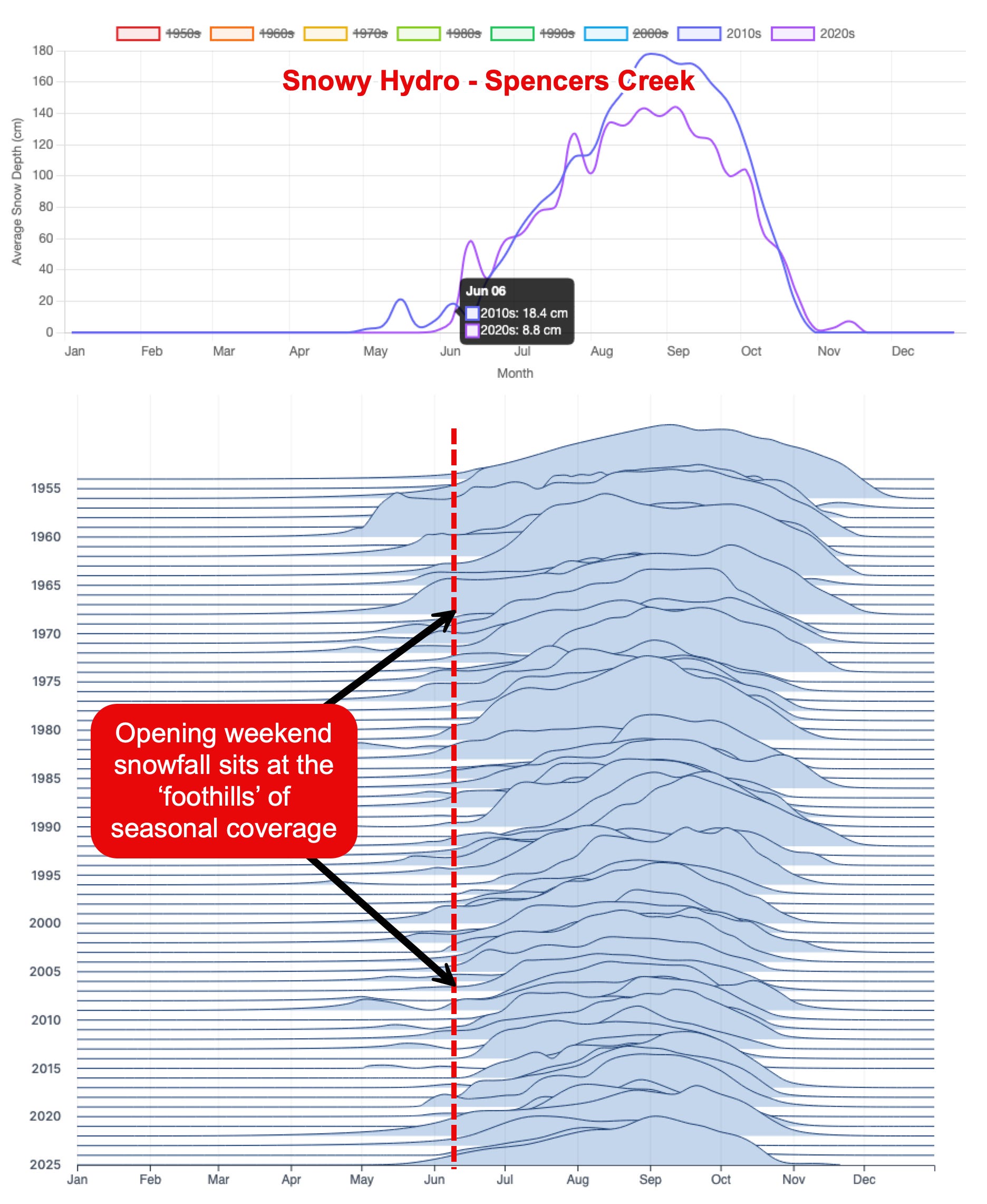
Current long-range deterministic guidance broadly supports that climatological trend, with several major models indicating a continued dominance of ridging through the back half of May and into early June. Under this scenario, Australian resorts could begin the 2026 season with little to no natural snow cover.
But there’s more to it than that…
Short Term Outlook
There remains a moderate-confidence chance of high-elevation snow Tuesday night into Wednesday next week, though accumulations would likely be limited to a dusting at best if the moisture reaches the Alps. Current modelling indicates the associated trough would weaken and shunted southeast as a strengthening ridge builds to its west.

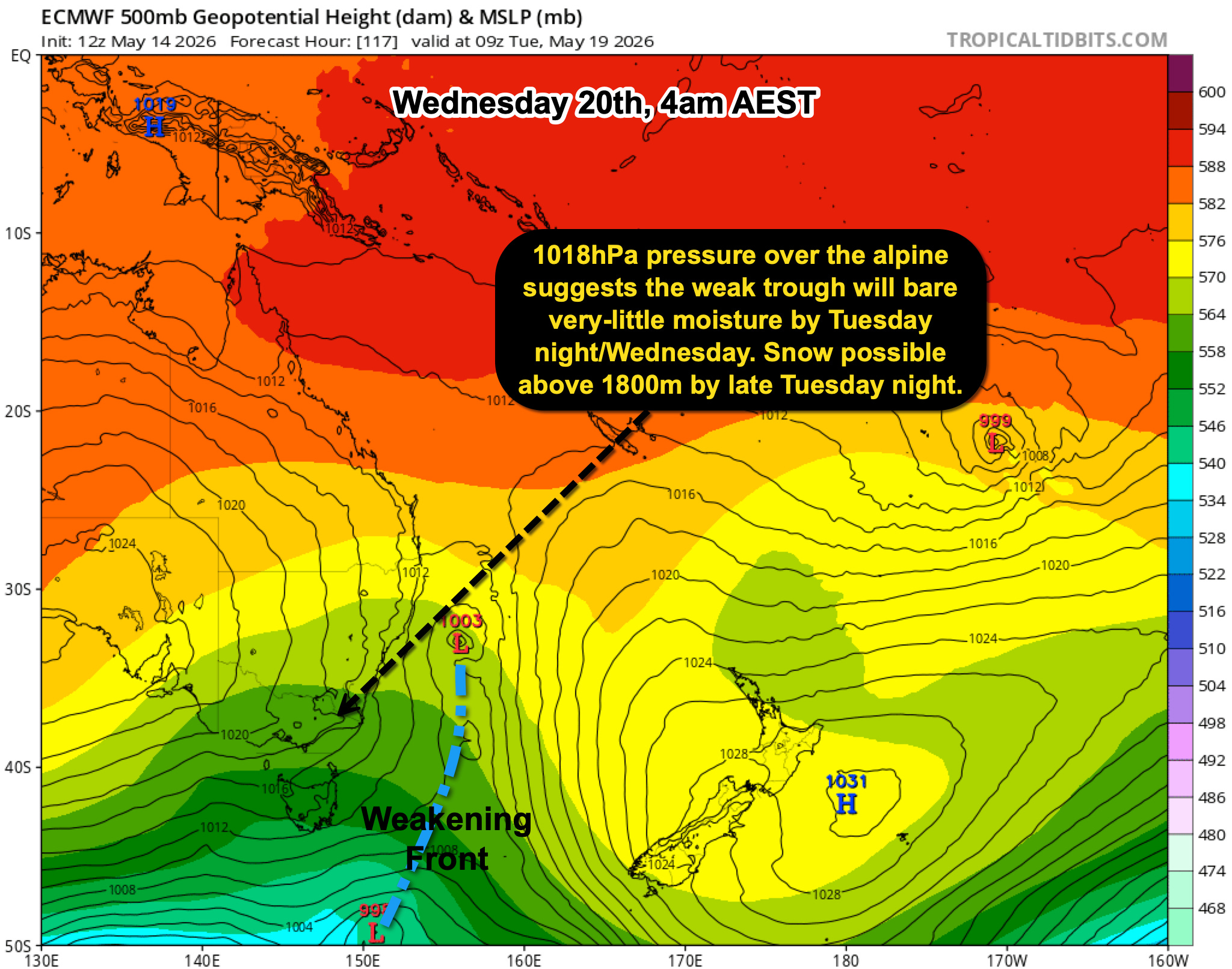
Temperatures may briefly become marginally supportive for snowmaking during overnight periods on Wednesday and Thursday, particularly if dew points remain favourable.
Long Range Outlook
If focusing solely on deterministic numerical guidance, the final week of May currently appears unlikely to produce any significant snow-bearing systems, largely due to the persistence of blocking highs — a pattern that is relatively common at this time of year and was discussed in the seasonal outlook published last week: HERE.
In the longer range, some guidance expects a system to move through southeastern Australia around 2–3 June, although confidence in the strength and positioning of that system has eased in recent runs.
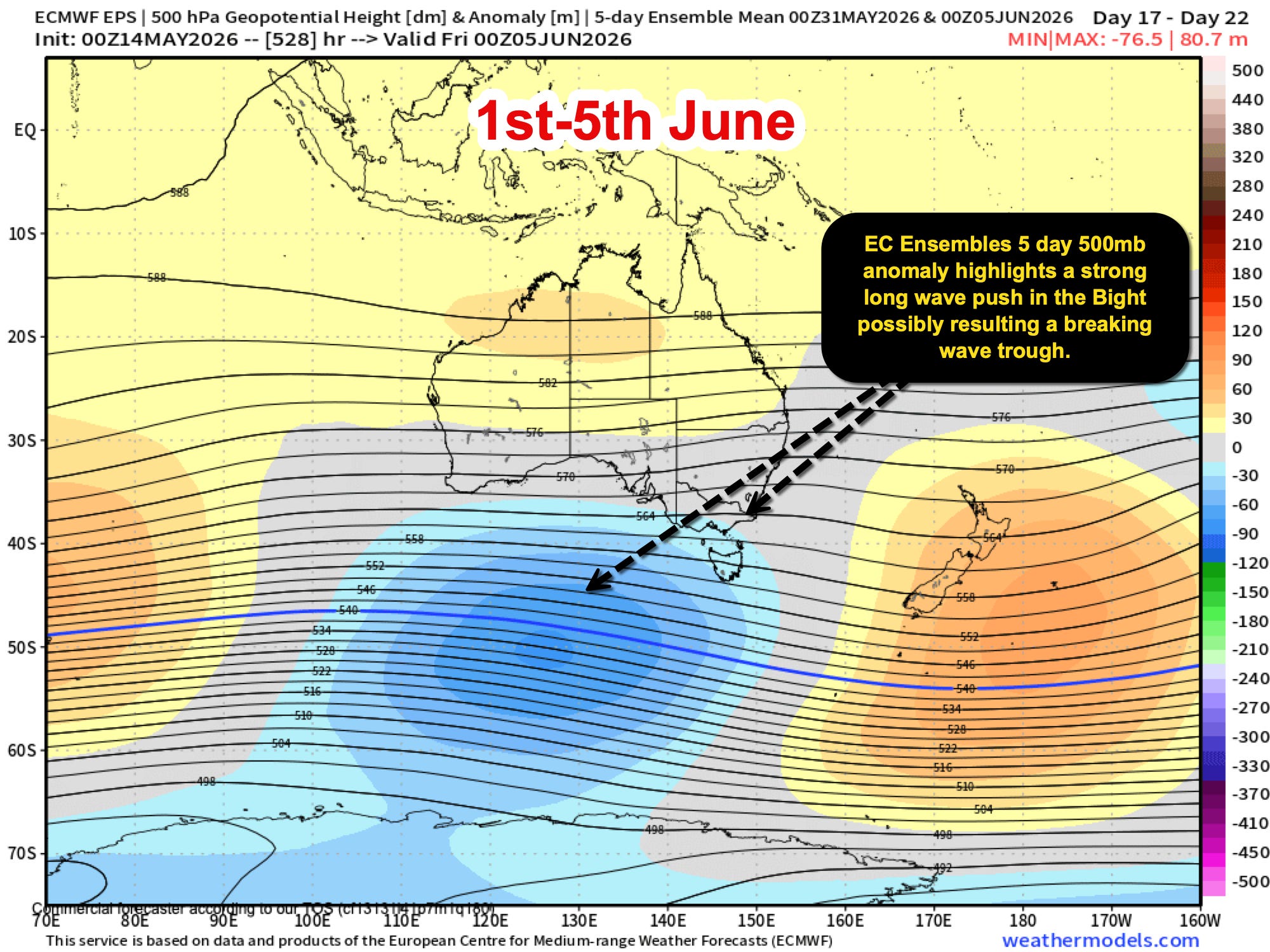
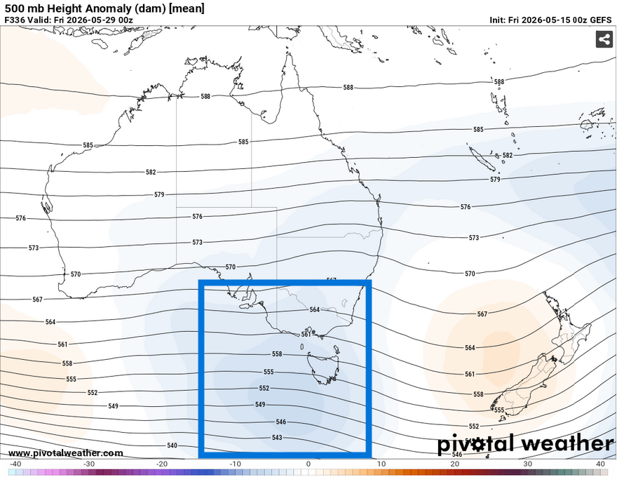
On the flipside, AI-assisted guidance has become somewhat more interesting over recent runs. While confidence remains low at this range, some probabilistic products — including ECMWF’s AI ensemble guidance — have begun indicating an increased likelihood of a long-wave trough peaking over southern Australia in the final days of May. At this stage, these signals remain in the balance, but they do suggest the broader pattern may remain more dynamic than deterministic runs imply.
EC’s AI Ensemble product highlights this potential with increasing negative (blue-shaded) anomalies in the period approaching the month’s end and possibly into the first few days of June:
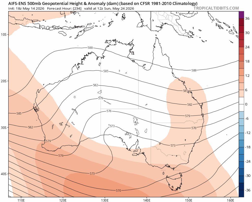
GFS Ensembles identifies a similar signal in the last few days of May; the signal is weak, largely due to the lead time of +300 hours:
Summary
Ultimately, the broader outlook remains highly fluid, with notable divergence continuing between deterministic and probabilistic guidance beyond the 7–10 day window. While traditional operational models currently favour a continuation of ridging and relatively mild conditions into early June, ensemble and AI-assisted products continue to intermittently signal the possibility of colder Southern Ocean air intruding into southeastern Australia toward the end of May and the opening days of winter.
At this lead time, confidence in any specific outcome remains low. Small shifts in the position and timing of blocking highs, troughs, and Southern Ocean wave activity could significantly alter the snowfall outlook over a relatively short period. For now, the outlook still leans toward a relatively dry and mild start to the season, although there are enough colder signals in the ensemble guidance to suggest it is too early to completely rule out a late-May or early-June change.
2027 Weather Workshop? Aye!? You reckon it’s got legs?
You tell me.
The Snowstack is considering running a small-group winter (Spring) backcountry weather workshop in 2027. The concept is to combine classroom-style learning with field-based observation and interpretation over 2–3 days in the Australian Alps, potentially alongside experienced guest contributors.


Before it’s explored further, I’d love to understand whether there’s genuine interest (from my loyal readership base!).
Let me know your thoughts by selecting the (anonymous) answers to these questions.
…And one last one.
What would make this genuinely worthwhile for you?
Is it:
Alpine weather and how it actually behaves in the field
Reading snow, wind and terrain in real time
Building confidence in interpreting conditions
Understanding forecasts beyond the app
Making better decisions in the backcountry
Is it something else?
Freestyle it and comment below, or feel free to email me at millartyson@gmail.com