Storms on Repeat: Mid-July Delivers a Critical Snow Stretch
With peak depth weeks ahead, the back-to-back systems through late July may define the season’s legacy.
Today, we see the start of a very obvious lean into the peak July storm cycle.
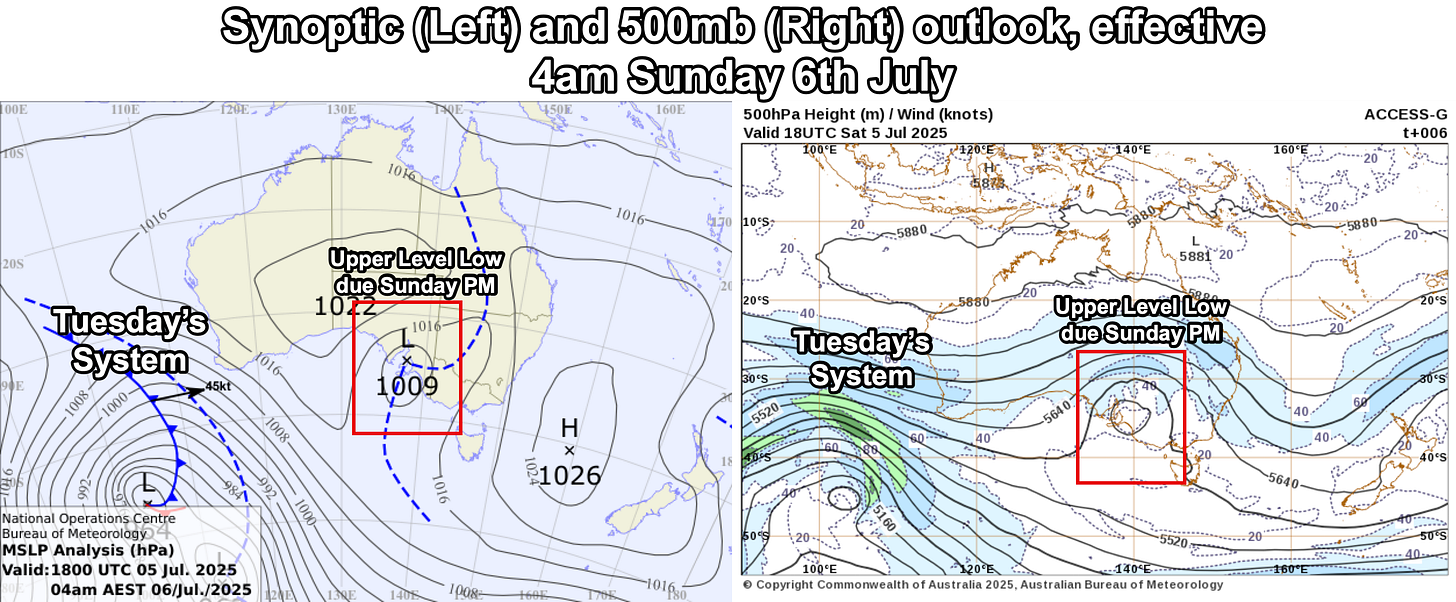
The current synoptic outlook shows a wandering upper-level cold pool centred over SE South Australia.
This low will move across the Alps this afternoon, bringing a brief window of moderate snow showers (above 1600 m) by around midday to 1 pm, as a north-eastern trough pushes through the alpine region from the north.
Some marginal precip is expected early this arvo, with snow falling to 1600m by this evening. The risk of convective snowfall (aka thundersnow) may increase for the northern slopes (Bimberies/Jugungal region) by late afternoon Sunday.
With light, low-level winds in place this afternoon, it’s likely to produce a serenely quiet snowfall — a rare and almost foreign experience in the Australian Alps.
An expected 6-10cm of snowfall is likely across the northern aspects by Monday morning.
A brief clearing trend will prevail in the south-east of the continent on Monday, ahead of the strong frontal feature arriving late on Tuesday.


Kicking off early Tuesday afternoon across the Victorian Alps, the first feature of the system pushes east-southeast after peaking in the Bight on Monday.
This two-part system is expected to deliver 10–15 cm of snow by Wednesday morning, with lingering snow showers continuing ahead of the second feature arriving Wednesday evening, likely bringing a further 20–25 cm by Thursday night.
Snowfall on Tuesday is expected to be heavy at times (4-7 pm local) thanks to the upper-level instability depicted above in the 500mb PV plot. Snow is expected to fall to 1400m on Tuesday, dropping to 1000m by Wednesday, ahead of the secondary feature Wednesday evening.
A significant polar airmass will accompany the heavy snowfall on Wednesday evening, dropping snow levels to around 900 m. By Thursday, the coldest air arrives, bringing periods of snowfall down to as low as 600 m in Victoria and 800 m in NSW.


25-40cm is expected from Tuesday through to Thursday afternoon, resort-dependent.
Strong winds will prevail throughout this period, with the most intense gusts expected during the initial front on Tuesday. Resort-level winds may impact lift operations from Tuesday morning onward, with conditions easing by Thursday afternoon.

Mixed conditions will persist from Thursday through to Sunday ahead of the next frontal feature, which is expected to persist into Tuesday, possibly offering a further 10-15cm to alpine areas. Model skill and precision vary for this system, so at this stage, expect feature changes for Sunday-Tuesday’s system.

Long Range Outlook
Supported by a persistent upper tropospheric node, we can expect a prolonged period of frontal activity into late July with a strong frontal push on the 20th of July, potentially impacting both SE Australia and NZ for 5-7 days. This outcome is uniquely supported by a wavenumber-3 pattern encircling the Southern (Antarctic) Hemisphere.


The key dates for southeast Australian snowfall appear to be the 19th and 26th of July, which look to coincide with some strong planetary wave drivers, namely the MJO (and sloping downward trend in SAM as a result).
Best July for some time by the looks!