


Take Your Seats: The Big Show Is About to Begin (With No Climate Driver)
A major system is approaching — the first front to swipe southeast Australia in six months—and models unanimously agree on one thing...

We’re currently in no man’s land. No established winter pattern and no real climate driver influence at play. Akin to being stuck at sea with a flooded engine - at the mercy of Mother Nature, a precariously unpredictable state.
It’s not a common way to see snow systems through the south-east, but if we ripped the engine cover off, this is what that proverbial flooded engine looks like:
The MJO was last seen about 10 days ago and is now in an “inactive“ phase.

NOAA just released this MJO update (19th May 2025):
“The MJO remains incoherent based on RMM observations and other fields. Kelvin Wave activity and a low frequency convective footprint near the Maritime Continent appear to remain the predominant modes of tropical variability since late March”
The ENSO influence is virtually non-existent as it sits in its neutral corner with no coherent influence on weather variability.

The IOD remains inactive until we start to see the onset of the northern Monsoon over the next month:
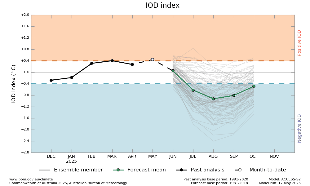
The Bureau's model predicts a neutral state of the IOD until at least July after which it forecasts a shift towards a negative IOD. This is consistent with 7 of 8 international models assessed which also forecast a negative IOD pattern developing at some point between June and September. Despite international model agreement, skill for IOD forecasts made at this time of year has been historically low beyond 1 to 2 months ahead. - BOM, 20th May 2025
The Southern Annular Mode (SAM) is trending towards an unfavourable positive phase:

With a stroke of luck—courtesy of a planetary disturbance known as a Kelvin Wave, energised by current convection over the Indo-Asian region—we're fortunate to see an isolated frontal system peak in the Bight this weekend. It’s a welcome anomaly: a deep low with strong winter characteristics, unusually robust for May.

Keep reading with a 7-day free trial
Subscribe to The Snowstack to keep reading this post and get 7 days of free access to the full post archives.