Skiing the Aussie Slow Season - July '23 Wrap Up
Climate drivers & late-June falls pointed to reasonable snowfall prospects in July but a key ingredient was missing.
The July Run Down & Climatic Indicators
Spencers Creek mean reading of 120.8 cm for July ‘23 still sits well-above the 10-year (‘12-’22) mean of 87.3 cm
The atmospheric coupling of the El Nino marine signal in July was weak
Southern Annular Mode (SAM) remained favourably neutral-negative for much of July
Indian Ocean Diople (IOD) currently has no influence on the Aus region
Considerably weakened Amundsen Sea Low (ASL) in July, prompted our region to be dominated by ridging
A robust Stratospheric Polar Vortex (SPV) underwent a warming phase in late July
ENSO - Isn’t it ‘El Nino’ already?!
BoM’s climate bulletin on the 1st August says ‘no El Nino’, yet. Now, that’s ok given that a El Nino call would indicate drier conditions across the alpine and continental Aus.
So why does it matter?
Well, for a favourable Aus snow outlook we ideally want to see ‘neutral’ ENSO conditions. When coupled with other drivers, this ‘nuetral’ ENSO favours some of Australia’s deepest snow base seasons.
Research paper: Neutral ENSO favours statically deeper snow bases
ENSO and more prescisely El Nino, has been getting a bad wrap in the media lately. But this is largely due to the grim long-term outlook for next summer rather than whats currently on the table.
In short, the sea-surface El Nino is undisputably present in the Pacific Ocean at the moment, however El Nino is a marine/atmospheric coupled driver so it needs that atmospheric component to have an impact on snow.
As per BOM’s call on Monday, we’re not quite there yet. Here’s why:
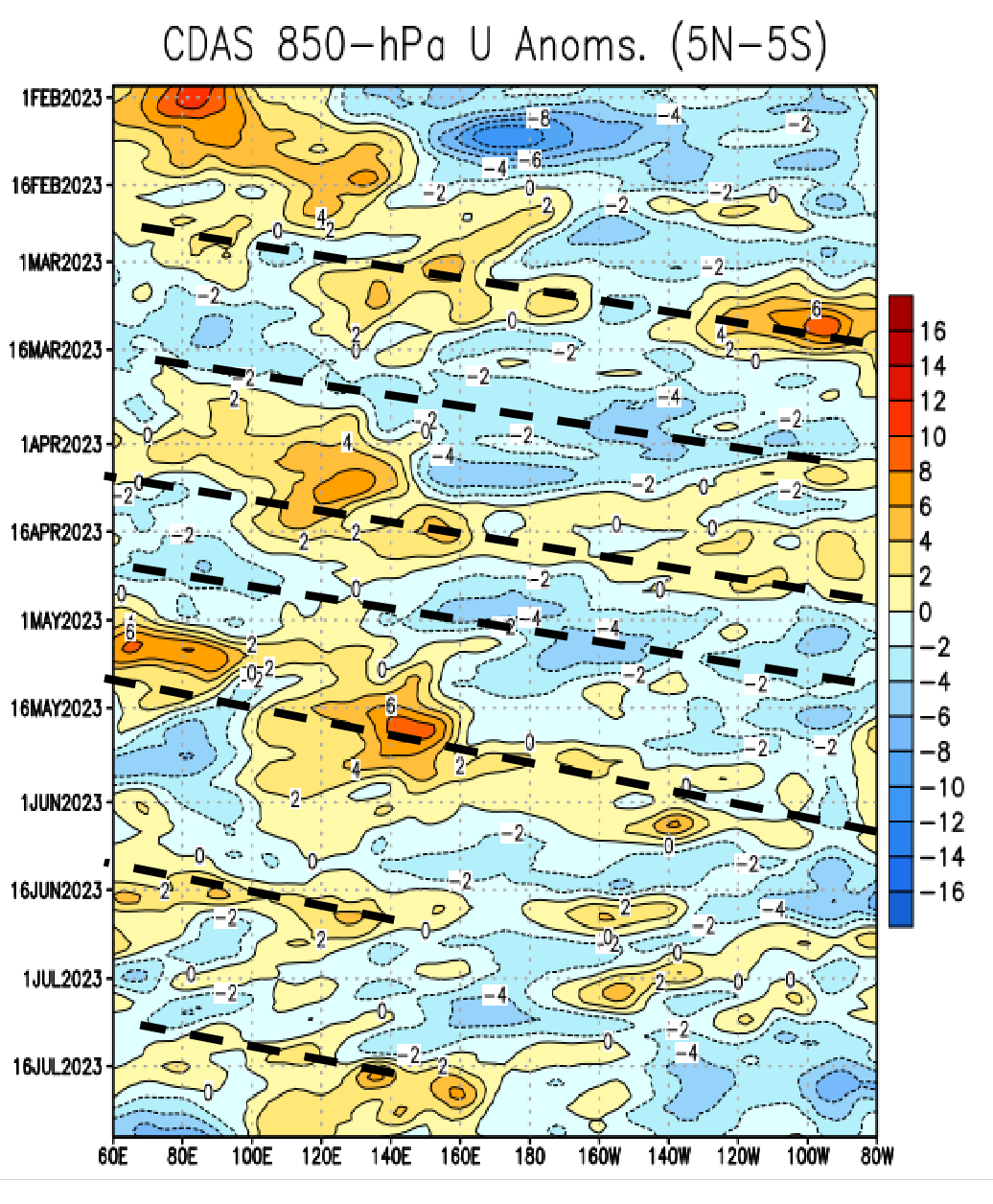
Trade winds are the low-level, tropical winds that blow from east-to-west. On the below timescale chart the yellow/red shading (positive values) represent westerly winds, while the teal/blue are easterlies (negative). The atmospheric signature we look for in terms of ENSO is in the Pacific, so between longitudes of c. 160E-90W.
The dashed lines represent the presence of westerly & easterly wind events propergating eastwards. In an El Nino phase, these trade winds weaken and in some areas of the Pacific they’ll even reverse to westerly.
Evidently we saw hints of it in April-May but there were other unrated factors involved.
Since mid-July, easterly wind anomalies persisted over the eastern Pacific Ocean, which is largely suggestive of a neutral ENSO phase.
The presence of the following events, has also muddied the waters of declaring El Nino:
An persistently semi-active tropical low in the western Pacific
Cloudiness (deep convection/storms) detected along the equator and particularly in the western Pacific
Blue shading in the below diagram highlights negative outgoing long wave radiation (OLR) anomalies which highlight regions of clouds and storms, while red shading is positive anomalies highlighting clear, cloudfree atmosphere.
Keep reading with a 7-day free trial
Subscribe to The Snowstack to keep reading this post and get 7 days of free access to the full post archives.


