Feast From The East
A moisture-laden feed out of the Tasman will undercut polar air early next week delivering an abundance of snow to the Australian Alpine.
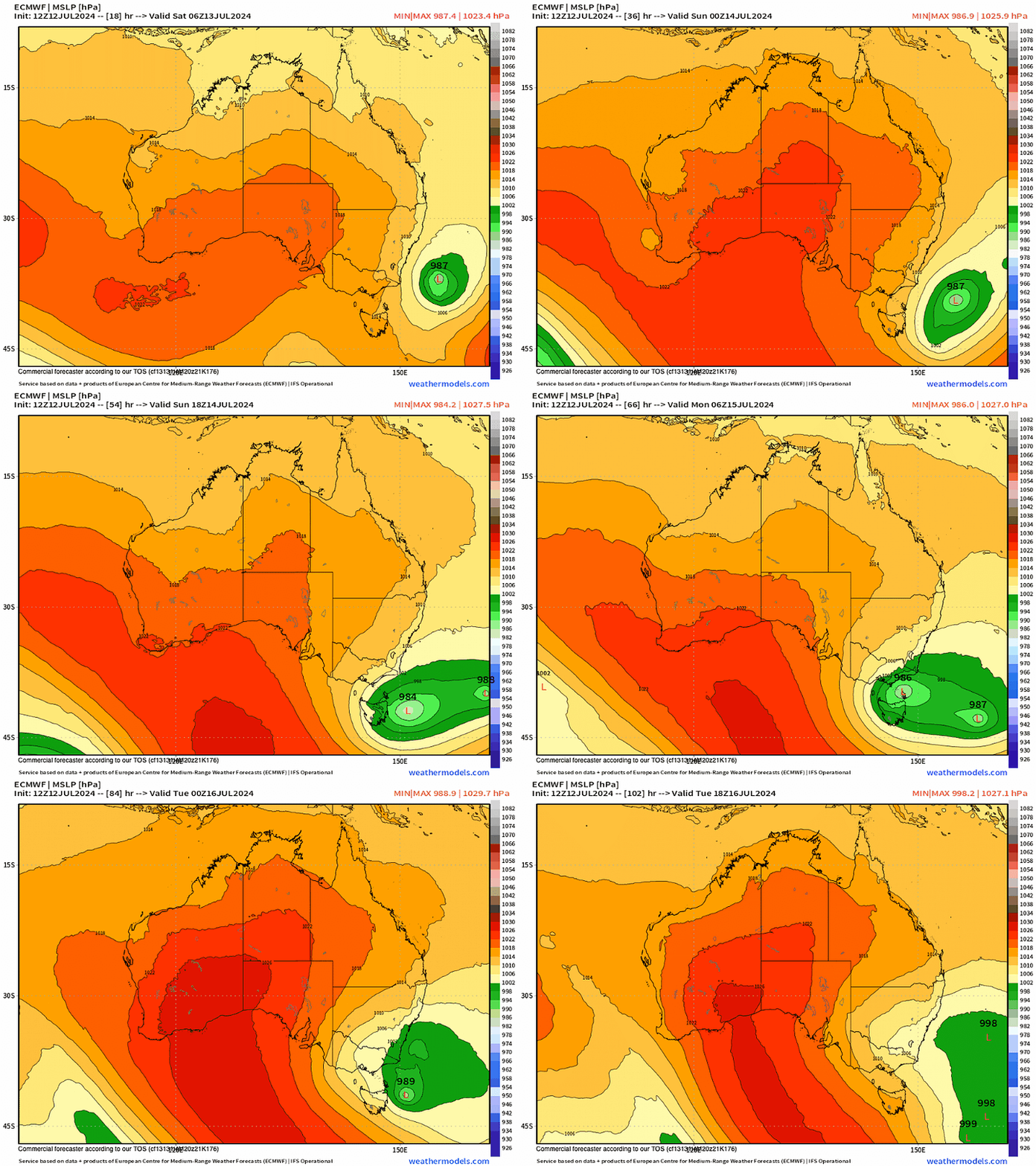
A low forming off the NSW south coast today initiates a rare sequence of events, potentially creating the Australian mainland's biggest snow system of the season (so far). It’s rare in the sense that we see a moisture feed tracking up and around Tasmania, all-the-while supported by polar air up the western flank.
Sunday evening to Wednesday should see 30-50cm of new snow across the Australian alpine ski areas, with some areas possibly seeing 2 feet by Wednesday.
Once deepening to sub-990 hPa central pressure, the low tracks westwards towards Tasmania. A westward transiting low down the eastern seaboard highlights the uniqueness of this system - unshackled by jetstream influence. Its meandering nature makes it highly unpredictable, however the models appear to show good agreement to suggest the low will further deepen and sucker punch the SE (non-techical term).


By Monday afternoon the low tracks its way up eastern Tasmania impacting the coast head on. Falls of 80-100mm are likely throughout SE Tasmania and Hobart. Monday looks generally rotten & sodden for SE Tasmania.
Gusty winds of 30-40 knots will hammer the coastline on Monday. Snow for the NE Tasmania’s ski area of Ben Lomond (~1500m) will be scarce as the warm origins of the low aren’t cool enough for freeze levels to sink below 1500m during daylight hours.
Next stop, Gippsland & the alpine.
Throughout Monday the alpine will see increasing snow shower activity as the low moves up the Tasmanian east coast. These showers will be supported by polar air to warrant snow to 1100m ASL.
By Monday night, the NSW & Victorian alpine will see heavy snow above 1300m.
Anomolous sea surface warm eddies to the east of Tasmania will provide added moisture for the low.
Heading into Tuesday, the low is in the sweet spot, positioned just off Gabo Island, allowing it’s broad westerly flank to circumvent Tasmania.
Usually, these types of systems are constrained by the Tasmanian rain shadow & topography, however this system circulates moisture around Tasmania on Monday, leading to a pseudo Sou-Wester delivery to Western Vic.
This scenario should favour Mount Baw Baw, and to a lesser extent, Mount Buller. Models suggest Mount Baw Baw could stand to receive 50-65cm of new snow by Wednesday.
Most of the global models suggest we’ll see snow showers taper-off on Wednesday, along with the climbing temps.
Minor Sudden Stratospheric Warming (SSW) Event
A couple of weeks ago, The Snowstack covered the potential of a anomalous SSW event to take place throughout July.
Keep reading with a 7-day free trial
Subscribe to The Snowstack to keep reading this post and get 7 days of free access to the full post archives.


