


Australian Alps in the Crosshairs of a Two-Part Polar System Next Week
Back-to-back cold fronts driven by a strong polar node set to shape snowfall prospects from 8–14th July.


A June Recap
June has wrapped for another year, and the Australian Alpine saw glimpses of gold during the opening month of the winter season. In conclusion, here’s how June shaped up around the resorts:
June 2025 delivered a tale of two regions. In the NSW Alps, Perisher and Thredbo bucked early-season outlooks with cooler days, slightly warmer nights, and above-average precipitation. Resorts saw near-average precipitation for June, with Perisher logging only 24 mm more precip than average. It might also be worth noting that Thredbo’s AWS (BOM managed) is unreliable for precip accumulation throughout negative temps.
In contrast, the Victorian resorts were cooler overnight but drier than normal, however Falls Creek and Mount Buller finishing 40 mm below average (~40% down on climate average). These early-season signals reinforce the growing variability across the alpine, despite favourable snow-bearing systems, which hint at the challenges ahead as we lean deeper into winter.


The Outlook
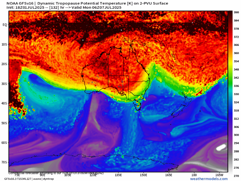
A brief window of snowfall is expected late on this Sunday (6th), following a weakened frontal system, providing a minor snowfall across the alpine elevations. The main event unfolds as a significant polar node, currently positioned over the midlatitudes of southwestern Western Australia on 7th July, advances eastward toward the southeast Australian coast late Tuesday, 8th July. This migrating feature will drive a two-stage frontal system across the region, marking a distinct period of increased meridional flow and polar air intrusion from the South. The node’s movement supports enhanced moisture transport and cold air advection from high latitudes (from the South). This sets the stage for significant weather changes in the Australian Alps, including lower snow levels and gusty winds. A temporary clearing trend of approximately 36 hours is expected between the two fronts before the next large-scale trough influences the region.

A brief initial snowfall event is expected by Monday morning (7 July), with 2–5 cm possible across alpine resorts as a weakened frontal system passes through. The main polar-driven system then takes hold, delivering a more substantial snowfall by Wednesday morning. Snowfall is forecast to lower to approximately 800 m elevation, with alpine resorts likely to accumulate 15–25 cm by this time.
Persistent zonal westerly flow is expected to maintain precipitation through Wednesday afternoon and into Thursday, adding a further 10–25 cm of snow to resort areas. This steady snowfall, combined with cold air advection, will enhance snowpack depths through the midweek period.
Following this, a ~36-hour clearing window is projected before the arrival of the secondary, more vigorous frontal system, late on Sunday, 13th July. This feature is forecast to deliver an additional 20–30 cm of snow, driven by a deeply cold air mass. Snowfall may reach as low as 700 m in Victoria and 800 m in southeastern New South Wales, owing to the strong polar influence and enhanced atmospheric instability.
Snowfall is also likely to present in high-elevation locations of the central tablelands and possibly the NSW’s Southern Highlands.
Taking a conservative approach, current guidance supports a total of 30–45 cm of snowfall across the alpine region between 8–14 July. This includes accumulations from both the midweek polar system and the stronger frontal feature forecast to arrive Sunday 13 July. While elevation, wind exposure, and timing will influence localised totals, the broader pattern suggests a productive week ahead for snowpack development—particularly at higher elevations—with snow likely extending to lower slopes during colder phases of the event.
While upper-range totals should be viewed with caution given the extended lead time, current signals suggest the alpine region could receive 40–60 cm by Monday week, following the passage of both systems.