


A Pause on Australian Snow Systems as NZ Cops The Big Chill
A recap on June's stellar end and NZ picks up it's first major cold shot.

Two north-west cloud bands this week ushered eastwards into the Tasman
Aus alpine: SW’ly flow and a cradling high dominate the alpine over the next week
Aus snow-bearing systems possibly return around the school holidays
NZ: South Island sea-level snow with 20-30cm possible in the resorts
The Recap
It’s been a fruitful 7-10 days for the Australian alpine region and whilst many media outlets talked dirty on opening weekend, we can be thankful for nearly a metre snowbase in parts of the alpine as we head into July.
In yesterday’s snow report, Perisher emptied its purse announcing 76cm of new snow over the last week, Thredbo announced 60cm and Mount Hotham 66cm. Falls Creek also announced in its Monday report it has an average natural snow depth of 97cm, plus whatever fell on Monday.
Can’t argue over rulers when your webcam looks like this at stumps on Monday (season accumulative):

Hypothetically, if Snowy Hydro were to measure Spencers Creek this week, assuming it exceeded 100cm (57cm registered on the 21st), then it would be the deepest 1st July snow pack since 2014, and the second deepest of the last 11 years.
So with 2 weeks of back-to-back snow systems, what gives?
Using ECMWF’s Time-longitudes diagram, it’s easy to identify that the last 5 days of snowfall have been adequately supported by good polar systems.

Where the blue contours intersect with ~140°E parallel is where the alpine is likely to see (or has seen) snowfalls. In a general sense, a lot of the systems in recent weeks have reached peak intensity around the Australian Bight, upstream of the alpine region.
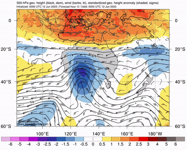
Here’s how the systems have presented on the upper-level (500mb) anomaly chart. Note the peak intensity (purple) ‘landing’ in the Bight between 120-140°E parallel.


In my last post I also discussed the potential for rain to be accompanied by the north-west cloudband. Despite the deluge in the NW, models have since aligned to the prospect of both moisture feeds being directed eastwards through central NSW into the Tasman, north of the alpine region.

The next NW cloud band will move through NT & Queensland this weekend.
So, back to snow, what’s with all the low-pressure systems peaking in the Bight?
Keep reading with a 7-day free trial
Subscribe to The Snowstack to keep reading this post and get 7 days of free access to the full post archives.